
Thank you for supporting this site ❤️
Make a donation
Make a donation
Gear up for your next adventure:
As an Amazon Associate, this site earns from qualifying purchases at no extra cost to you.
Ash Sha`bayn topographic map
Click on the map to display elevation.
Thank you for supporting this site ❤️
Make a donation
Make a donation
Gear up for your next adventure:
As an Amazon Associate, this site earns from qualifying purchases at no extra cost to you.
About this map
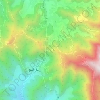
Name: Ash Sha`bayn topographic map, elevation, terrain.
Location: Ash Sha`bayn, Rijal Almaa, 'Asir Province, Saudi Arabia (18.20016 42.25984 18.24016 42.29984)
Average elevation: 1,334 m
Minimum elevation: 900 m
Maximum elevation: 2,017 m
Thank you for supporting this site ❤️
Make a donation
Make a donation
Gear up for your next adventure:
As an Amazon Associate, this site earns from qualifying purchases at no extra cost to you.