Geolocate

Charo topographic map

Click on the map to display elevation.

About this map

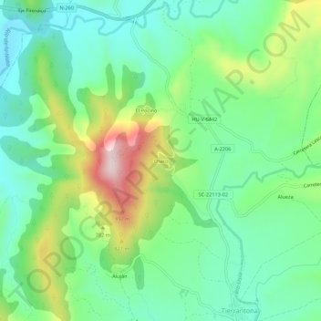
Name: Charo topographic map, elevation, terrain.

Location: Charo, La Fueva, Sobrarbe, Huesca, Aragón, 22337, España (42.36954 0.23854 42.40954 0.27854)

Average elevation: 694 m

Minimum elevation: 565 m

Maximum elevation: 976 m

Other topographic maps

Click on a map to view its topography, its elevation and its terrain.

Boltaña

España > Aragón > Sobrarbe

Average elevation: 859 m

Tella-Sin

España > Aragón > Sobrarbe

Average elevation: 1,448 m

Embalse de Mediano

España > Aragón > Sobrarbe

Average elevation: 649 m

La Fueva

España > Aragón > Sobrarbe

Average elevation: 923 m

Cañón de Añisclo

España > Aragón > Sobrarbe

Average elevation: 1,487 m

Gear up for your next adventure:

🧰Survival Kit - Essential gear for emergencies in the wilderness
💧Reusable Water Bottle - Durable water bottles for hydration on trails
🧢Hiking Sun Hat - Wide-brimmed protection for exposed mountain ridges
🥾Hiking Boots - Sturdy boots providing ankle support and traction on rugged trails
🥾Lightweight Hiking Boots - Boots for comfort and mobility on long hikes

As an Amazon Associate, this site earns from qualifying purchases at no extra cost to you.