
Make a donation
Gear up for your next adventure:
As an Amazon Associate, this site earns from qualifying purchases at no extra cost to you.
Ain Antar topographic map
Click on the map to display elevation.
Make a donation
Gear up for your next adventure:
As an Amazon Associate, this site earns from qualifying purchases at no extra cost to you.
About this map
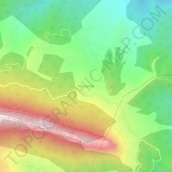
Name: Ain Antar topographic map, elevation, terrain.
Location: Ain Antar, Boucaïd, Daïra Lazharia, Tissemsilt, Algérie (35.87626 1.65515 35.91626 1.69515)
Average elevation: 991 m
Minimum elevation: 537 m
Maximum elevation: 1,641 m
Make a donation
Gear up for your next adventure:
As an Amazon Associate, this site earns from qualifying purchases at no extra cost to you.
Other topographic maps
Click on a map to view its topography, its elevation and its terrain.
Boucaïd
Algérie > Tissemsilt > Daïra Lazharia
Le chef lieu de la commune de Boucaid se distingue par son implantation à près de 1 200 mètres d'altitude au pied de l'Ouarsenis, ce qui en fait l'une des communes les plus élevées d’Algérie. Boucaid se situe à 250 km à l'ouest d'Alger et à 64 km au nord du chef lieu de la wilaya Tissemsilt.
Average elevation: 862 m