Geolocate

Köping topographic map

Click on the map to display elevation.

About this map

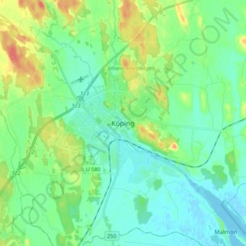
Name: Köping topographic map, elevation, terrain.

Location: Köping, Köpings kommun, Västmanland County, 731 32, Sweden (59.47374 15.95705 59.55374 16.03705)

Average elevation: 15 m

Minimum elevation: -3 m

Maximum elevation: 57 m

Other topographic maps

Click on a map to view its topography, its elevation and its terrain.

Sala kommun

Sweden > Västmanland County

Average elevation: 72 m

Köpings kommun

Sweden > Västmanland County

Average elevation: 50 m

Gear up for your next adventure:

📷Outdoor Action Camera - Capture high-elevation views and rugged adventures
🪜Heavy Duty Carabiners - Multi-use clips for securing gear to your backpack
🔦LED Headtorch - Bright and durable light for night activities
🔭Compact Binoculars - Lightweight optics for scouting trails and wildlife
💡Compact LED Flashlight - Powerful and portable flashlight for outdoor use

As an Amazon Associate, this site earns from qualifying purchases at no extra cost to you.