
Make a donation
Gear up for your next adventure:
As an Amazon Associate, this site earns from qualifying purchases at no extra cost to you.
Teufelskopf topographic map
Click on the map to display elevation.
Make a donation
Gear up for your next adventure:
As an Amazon Associate, this site earns from qualifying purchases at no extra cost to you.
Teufelskopf
Der Teufelskopf ist laut einem auf topographischen Karten verzeichneten trigonometrischem Punkt im Bereich des Senders Teufelskopf mindestens 695 m hoch. Wenige Meter südwestlich vom Gipfel befindet sich eine 694,3 m hohe Stelle. Im Südwesten der Gipfelregion ist auf derartigen Karten etwa in Ovalform eine 695-m-Höhenlinie ohne weitere Höhenangabe zu finden, so dass es möglich ist, dass die Erhebung im Inneren dieses Ovals noch etwas höher als 695 m ist. Etwas ostnordöstlich des Gipfels liegt eine Waldwegkreuzung auf 685 m Höhe.
Make a donation
Gear up for your next adventure:
As an Amazon Associate, this site earns from qualifying purchases at no extra cost to you.
About this map
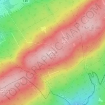
Name: Teufelskopf topographic map, elevation, terrain.
Average elevation: 610 m
Minimum elevation: 473 m
Maximum elevation: 701 m
Make a donation
Gear up for your next adventure:
As an Amazon Associate, this site earns from qualifying purchases at no extra cost to you.