
Thank you for supporting this site ❤️
Make a donation
Make a donation
Gear up for your next adventure:
As an Amazon Associate, this site earns from qualifying purchases at no extra cost to you.
Jebel M'Goun topographic map
Click on the map to display elevation.
Thank you for supporting this site ❤️
Make a donation
Make a donation
Gear up for your next adventure:
As an Amazon Associate, this site earns from qualifying purchases at no extra cost to you.
Jebel M'Goun
L'ighil M'Goun, avec ses 4 071 mètres d'altitude, constitue le troisième plus haut sommet du Maroc après le djebel Toubkal (4 167 mètres) et le djebel Ouanoukrim (4 089 mètres au Timzguida).
Thank you for supporting this site ❤️
Make a donation
Make a donation
Gear up for your next adventure:
As an Amazon Associate, this site earns from qualifying purchases at no extra cost to you.
About this map
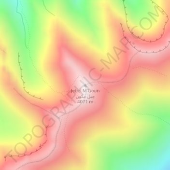
Name: Jebel M'Goun topographic map, elevation, terrain.
Average elevation: 3,689 m
Minimum elevation: 3,158 m
Maximum elevation: 4,064 m
Thank you for supporting this site ❤️
Make a donation
Make a donation
Gear up for your next adventure:
As an Amazon Associate, this site earns from qualifying purchases at no extra cost to you.