Geolocate

Danao topographic map

Click on the map to display elevation.

About this map

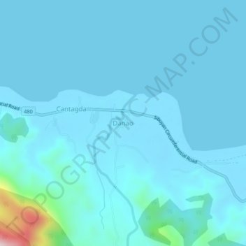
Name: Danao topographic map, elevation, terrain.

Location: Danao, Cajidiocan, Romblon, Mimaropa, Philippines (12.46794 122.60672 12.50794 122.64672)

Average elevation: 29 m

Minimum elevation: 0 m

Maximum elevation: 412 m

Gear up for your next adventure:

🧦Thermal Socks - Warm socks for winter hiking or camping
💡Solar Camping Lamp - Eco-friendly lighting for campsites
🥾Approach Shoes - Shoes designed for climbing approaches and rugged trails
🧼Biodegradable Camp Soap - Environmentally friendly cleaning for gear and body
🔪Outdoor Multitool - Versatile tool for repairs and food prep in the wild

As an Amazon Associate, this site earns from qualifying purchases at no extra cost to you.