Geolocate

Mt.Tai topographic map

Click on the map to display elevation.

About this map

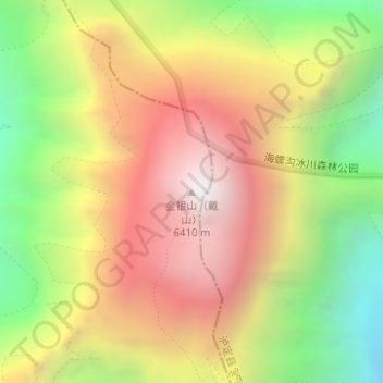
Name: Mt.Tai topographic map, elevation, terrain.

Location: Mt.Tai, Kangding, Kardze, Sichuan, 626000, China (29.52476 101.92504 29.52486 101.92514)

Average elevation: 5,585 m

Minimum elevation: 4,747 m

Maximum elevation: 6,372 m

Other topographic maps

Click on a map to view its topography, its elevation and its terrain.

贡巴冰川

China > Sichuan > Kangding

Average elevation: 5,375 m

康定跑马山风景区

China > Sichuan > Kangding > Jingangsi

Average elevation: 2,804 m

Gear up for your next adventure:

🧦Merino Wool Socks - Moisture-wicking comfort for long-distance hiking
🥾Trail Hiking Boots - Supportive boots for rough trails
🐕Hiking Dog Pack - Let your canine companion carry their own water and food
🥾Mountaineering Boots - Supportive boots for climbing and high-altitude hiking
🥾All-Terrain Hiking Boots - Versatile boots for varied hiking conditions

As an Amazon Associate, this site earns from qualifying purchases at no extra cost to you.