Geolocate

Dahlonega topographic map

Click on the map to display elevation.

About this map

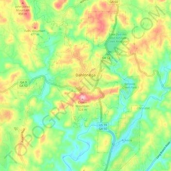
Name: Dahlonega topographic map, elevation, terrain.

Location: Dahlonega, Lumpkin County, Georgia, United States (34.48763 -84.02316 34.56806 -83.95058)

Average elevation: 411 m

Minimum elevation: 338 m

Maximum elevation: 522 m

Other topographic maps

Click on a map to view its topography, its elevation and its terrain.

Woody Gap

United States > Georgia > Lumpkin County

Average elevation: 891 m

Burtsboro

United States > Georgia > Lumpkin County

Average elevation: 453 m

Nimblewill

United States > Georgia > Lumpkin County

Average elevation: 528 m

DeSoto Falls

United States > Georgia > Lumpkin County

Average elevation: 858 m

Gear up for your next adventure:

🦯Trekking Poles - Reduced impact on joints for steep topographic climbs
🧭GPS Outdoor Watch - Smart watch for navigation and fitness tracking in nature
🧢Hiking Hat - Sun-protective and breathable hats for long treks
🥾Light Hiking Boots - Lightweight and comfortable boots for day hikes
🌬️Windproof Camp Stove - Efficient cooking even on exposed mountain peaks

As an Amazon Associate, this site earns from qualifying purchases at no extra cost to you.