
Thank you for supporting this site ❤️
Make a donation
Make a donation
Gear up for your next adventure:
As an Amazon Associate, this site earns from qualifying purchases at no extra cost to you.
Kedaluh topographic map
Click on the map to display elevation.
Thank you for supporting this site ❤️
Make a donation
Make a donation
Gear up for your next adventure:
As an Amazon Associate, this site earns from qualifying purchases at no extra cost to you.
About this map
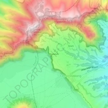
Name: Kedaluh topographic map, elevation, terrain.
Location: Kedaluh, Cemorolawang, Probolinggo, Java, 67254, Indonesia (-7.93382 112.93891 -7.89382 112.97891)
Average elevation: 2,282 m
Minimum elevation: 1,939 m
Maximum elevation: 2,749 m
Thank you for supporting this site ❤️
Make a donation
Make a donation
Gear up for your next adventure:
As an Amazon Associate, this site earns from qualifying purchases at no extra cost to you.