
Make a donation
Gear up for your next adventure:
As an Amazon Associate, this site earns from qualifying purchases at no extra cost to you.
Pegunungan Arfak topographic map
Click on the map to display elevation.
Make a donation
Gear up for your next adventure:
As an Amazon Associate, this site earns from qualifying purchases at no extra cost to you.
Pegunungan Arfak
Geographical Location of Arfak Mountains Regency, as follows: Part North : 0º55' South Latitude; Southern Part: 1º40' South Latitude; Part West : 133º10' East Longitude; East: 134º05' East Longitude. The altitude of the Arfak Mountains Regency is 300 – 1,800 metres above sea level.
Make a donation
Gear up for your next adventure:
As an Amazon Associate, this site earns from qualifying purchases at no extra cost to you.
About this map
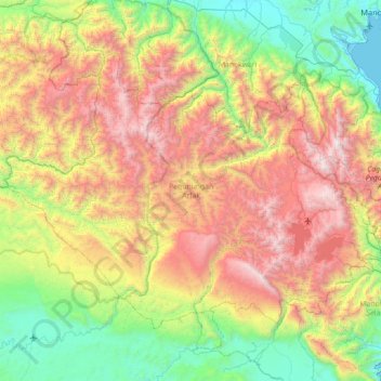
Name: Pegunungan Arfak topographic map, elevation, terrain.
Location: Pegunungan Arfak, West Papua, Western New Guinea, Indonesia (-1.57072 133.23000 -0.95195 134.08525)
Average elevation: 1,115 m
Minimum elevation: 0 m
Maximum elevation: 2,913 m
Make a donation
Gear up for your next adventure:
As an Amazon Associate, this site earns from qualifying purchases at no extra cost to you.
Other topographic maps
Click on a map to view its topography, its elevation and its terrain.
Make a donation
Gear up for your next adventure:
As an Amazon Associate, this site earns from qualifying purchases at no extra cost to you.
Make a donation
Gear up for your next adventure:
As an Amazon Associate, this site earns from qualifying purchases at no extra cost to you.
Make a donation
Gear up for your next adventure:
As an Amazon Associate, this site earns from qualifying purchases at no extra cost to you.