Geolocate

Budbud topographic map

Click on the map to display elevation.

About this map

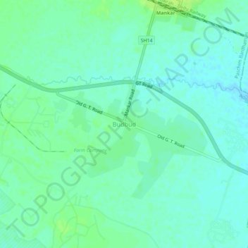
Name: Budbud topographic map, elevation, terrain.

Location: Budbud, Galsi - I, Purba Bardhaman, West Bengal, India (23.38142 87.52751 23.42142 87.56751)

Average elevation: 57 m

Minimum elevation: 52 m

Maximum elevation: 64 m

Gear up for your next adventure:

🚲Bike Repair Kit - Essential tools for on-trail mechanical issues
🥾Light Trekking Boots - Supportive boots for multi-day treks
🧣Evaporative Cooling Towel - Beat the heat during intense summer climbs
Backpacking Tent - Lightweight tent for long-distance hiking trips
Camping Essentials - All-in-one gear for a comfortable camping trip

As an Amazon Associate, this site earns from qualifying purchases at no extra cost to you.