
South East Constituency 1947 topographic map
Interactive map
Click on the map to display elevation.
About this map
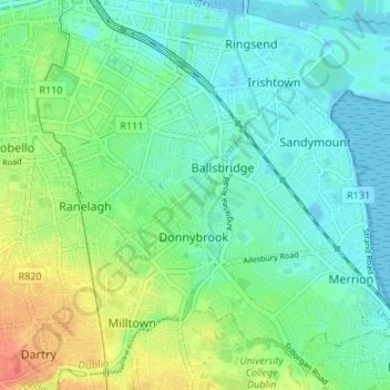
Name: South East Constituency 1947 topographic map, elevation, terrain.
Average elevation: 14 m
Minimum elevation: -2 m
Maximum elevation: 45 m
Other topographic maps
Click on a map to view its topography, its elevation and its terrain.
African Savanna
African Savanna, Phoenix Park ED, Dublin 8, Dublin, County Dublin, Leinster, D08 HN3X, Ireland
Average elevation: 35 m
North Bull Island
North Bull Island, Raheny St. Assam ED, Dublin 5, Dublin, County Dublin, Leinster, Ireland
Average elevation: 2 m
Cherry Orchard
Cherry Orchard, Merchants Quay E ED, Dublin 8, Dublin, County Dublin, Leinster, Ireland
Average elevation: 25 m