
Make a donation
Gear up for your next adventure:
As an Amazon Associate, this site earns from qualifying purchases at no extra cost to you.
St. Veit an der Glan topographic map
Click on the map to display elevation.
Make a donation
Gear up for your next adventure:
As an Amazon Associate, this site earns from qualifying purchases at no extra cost to you.
About this map
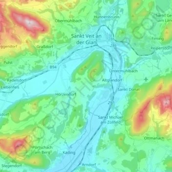
Name: St. Veit an der Glan topographic map, elevation, terrain.
Average elevation: 591 m
Minimum elevation: 450 m
Maximum elevation: 1,116 m
Make a donation
Gear up for your next adventure:
As an Amazon Associate, this site earns from qualifying purchases at no extra cost to you.
Other topographic maps
Click on a map to view its topography, its elevation and its terrain.
Make a donation
Gear up for your next adventure:
As an Amazon Associate, this site earns from qualifying purchases at no extra cost to you.
Pörlinghof
Österreich > Kärnten > Bezirk St. Veit an der Glan > Frauenstein > Überfeld
Average elevation: 597 m
Make a donation
Gear up for your next adventure:
As an Amazon Associate, this site earns from qualifying purchases at no extra cost to you.
Einöd
Österreich > Kärnten > Bezirk St. Veit an der Glan > Frauenstein > Kraig
Average elevation: 735 m
Make a donation
Gear up for your next adventure:
As an Amazon Associate, this site earns from qualifying purchases at no extra cost to you.
Rauscheggen
Österreich > Kärnten > Bezirk St. Veit an der Glan > Deutsch-Griffen
Average elevation: 1,188 m
Weindorf
Österreich > Kärnten > Bezirk St. Veit an der Glan > Sankt Georgen am Längsee
Average elevation: 612 m
Make a donation
Gear up for your next adventure:
As an Amazon Associate, this site earns from qualifying purchases at no extra cost to you.
Make a donation
Gear up for your next adventure:
As an Amazon Associate, this site earns from qualifying purchases at no extra cost to you.
Kötschendorf
Österreich > Kärnten > Bezirk St. Veit an der Glan > Weitensfeld im Gurktal
Average elevation: 947 m
Make a donation
Gear up for your next adventure:
As an Amazon Associate, this site earns from qualifying purchases at no extra cost to you.