
Make a donation
Gear up for your next adventure:
As an Amazon Associate, this site earns from qualifying purchases at no extra cost to you.
Olba topographic map
Click on the map to display elevation.
Make a donation
Gear up for your next adventure:
As an Amazon Associate, this site earns from qualifying purchases at no extra cost to you.
Olba
Olba liegt knapp 43 Kilometer (Fahrtstrecke) südöstlich der Provinzhauptstadt Teruel im Bergland der Sierra de Gúdar am Río Mijares in einer Höhe von ca. 660 m.
Make a donation
Gear up for your next adventure:
As an Amazon Associate, this site earns from qualifying purchases at no extra cost to you.
About this map
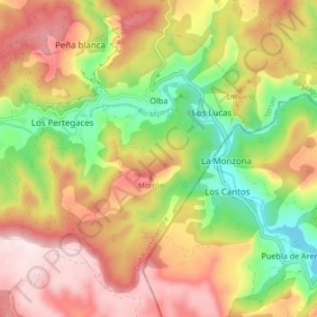
Name: Olba topographic map, elevation, terrain.
Location: Olba, Gúdar-Javalambre, Teruel, Aragonien, Spanien (40.09834 -0.67984 40.14602 -0.60595)
Average elevation: 817 m
Minimum elevation: 565 m
Maximum elevation: 1,058 m
Make a donation
Gear up for your next adventure:
As an Amazon Associate, this site earns from qualifying purchases at no extra cost to you.