Geolocate

Langogne topographic map

Click on the map to display elevation.

About this map
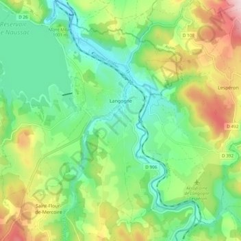
Name: Langogne topographic map, elevation, terrain.

Location: Langogne, Mende, Lozère, Occitania, Metropolitan France, 48300, France (44.68722 3.78961 44.75485 3.87774)

Average elevation: 996 m

Minimum elevation: 889 m

Maximum elevation: 1,198 m

Other topographic maps

Click on a map to view its topography, its elevation and its terrain.
Thonas

France > Occitania > Lozère > Saint-Germain-de-Calberte

Average elevation: 463 m

Gear up for your next adventure:

🚑Survival Whistle - Signal for help across long distances in mountains
🧦Thermal Socks - Warm socks for winter hiking or camping
🧥Waterproof Hiking Jacket - Protect yourself from rain and wind while hiking
🧢Outdoor Cap - Protective cap for sun and rain during hikes
🗺️Topographic Maps - Detailed maps to explore trails, mountains, and wilderness areas

As an Amazon Associate, this site earns from qualifying purchases at no extra cost to you.