Geolocate

Sipsipin topographic map

Click on the map to display elevation.

About this map

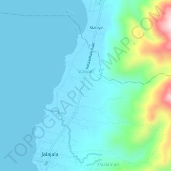
Name: Sipsipin topographic map, elevation, terrain.

Location: Sipsipin, Jalajala, Rizal, Calabarzon, 1990, Philippines (14.35745 121.32261 14.38260 121.36525)

Average elevation: 78 m

Minimum elevation: 2 m

Maximum elevation: 481 m

Other topographic maps

Click on a map to view its topography, its elevation and its terrain.

Maulawin

Philippines > Rizal > Jalajala > Bagumbong

Average elevation: 92 m

Pagkalinawan

Philippines > Rizal > Jalajala > Pagkalinawan

Average elevation: 38 m

Gear up for your next adventure:

🩹Moleskin Blister Pads - Direct protection for painful foot pressure points
🥾Waterproof Hiking Boots - Boots keeping your feet dry in wet conditions
🥾Light Hiking Boots - Lightweight and comfortable boots for day hikes
🛶Kayak Dry Bag - Waterproof storage for kayaking adventures
🕶️Polarized Sunglasses - Protect your eyes with durable polarized lenses

As an Amazon Associate, this site earns from qualifying purchases at no extra cost to you.