Geolocate

Santullán topographic map

Click on the map to display elevation.

Santullán

La localidad se encuentra a 110 metros de altitud sobre el nivel del mar, y a 3 kilómetros de la capital municipal, Castro-Urdiales.​

Wikipedia (CC-BY-SA 3.0)

About this map

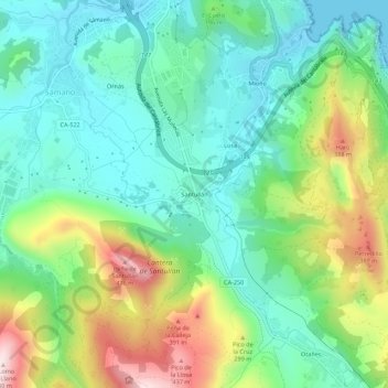
Name: Santullán topographic map, elevation, terrain.

Location: Santullán, Castro-Urdiales, Cantabria, 39706, España (43.32729 -3.23066 43.36729 -3.19066)

Average elevation: 148 m

Minimum elevation: -2 m

Maximum elevation: 470 m

Gear up for your next adventure:

🏕️Camping Hammock - Integrated protection for sleeping between trees
🔦LED Headlamp - Hands-free lighting for early morning starts or late finishes
🧴Sunscreen SPF - Broad-spectrum sunscreen for outdoor activities
💧Hydration Pack - Hands-free hydration system for long hikes
🛶Waterproof Dry Bags - Keep electronics and clothes dry during river crossings

As an Amazon Associate, this site earns from qualifying purchases at no extra cost to you.