
Make a donation
Gear up for your next adventure:
As an Amazon Associate, this site earns from qualifying purchases at no extra cost to you.
Gaderoth topographic map
Click on the map to display elevation.
Make a donation
Gear up for your next adventure:
As an Amazon Associate, this site earns from qualifying purchases at no extra cost to you.
Gaderoth
Auf der Hardt | Abbenroth | Ahebruch | Ahlbusch | Alsbach | Altennümbrecht | Bierenbachtal | Breunfeld | Benroth | Berkenroth | Birkenbach | Breitewiese | Brünglinghausen | Bruch | Büschhof | Buch | Distelkamp | Drinsahl | Elsenroth | Erlinghausen | Friedenthal | Gaderoth | Gerhardsiefen | Geringhausen | Geringhauser Mühle | Göpringhausen | Grötzenberg | Grünthal | Grunewald | Guxmühlen | Haan | Hammermühle | Hardt | Harscheid | Hasenberg | Heddinghausen | Heide | Heisterstock | Hillenbach | Hochstraßen | Höferhof | Hömel | Homburg-Bröl | Homburger Papiermühle | Huppichteroth | Kleinhöhe | Krahm | Kurtenbach | Langenbach | Linde | Lindscheid | Lindscheider Mühle | Loch | Löhe | Malzhagen | Marienberghausen | Mildsiefen | Mühlenthal | Nallingen | Neuenberg | Neuroth | Niederbröl | Niederbreidenbach | Niederelben | Niederstaffelbach | Nöchel | Oberbech | Oberbierenbach | Oberbreidenbach | Oberelben | Oberstaffelbach | Ödinghausen | Prombach | Riechenbach | Rommelsdorf | Röttgen | Rose | Schönhausen | Schönthal | Spreitgen | Stockheim | Stranzenbach | Straße | Überdorf | Unter der Hardt | Vorholz | Windhausen | Winterborn | Wirtenbach | Wolfscharre
Make a donation
Gear up for your next adventure:
As an Amazon Associate, this site earns from qualifying purchases at no extra cost to you.
About this map
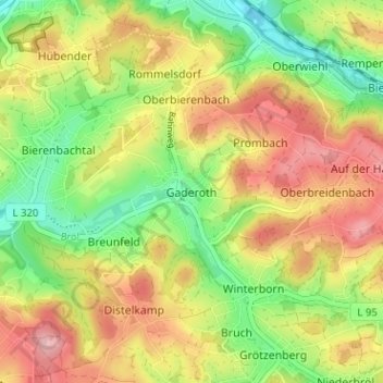
Name: Gaderoth topographic map, elevation, terrain.
Average elevation: 268 m
Minimum elevation: 196 m
Maximum elevation: 344 m
Make a donation
Gear up for your next adventure:
As an Amazon Associate, this site earns from qualifying purchases at no extra cost to you.
Other topographic maps
Click on a map to view its topography, its elevation and its terrain.
Kurpark Nümbrecht
Deutschland > Nordrhein-Westfalen > Oberbergischer Kreis > Nümbrecht > Ödinghausen
Average elevation: 280 m
Schloss Homburg
Deutschland > Nordrhein-Westfalen > Oberbergischer Kreis > Nümbrecht > Homburg-Bröl > Unter der Hardt
Average elevation: 257 m
Guxmühlen
Deutschland > Nordrhein-Westfalen > Oberbergischer Kreis > Nümbrecht > Marienberghausen
Auf der Hardt | Abbenroth | Ahebruch | Ahlbusch | Alsbach | Altennümbrecht | Bierenbachtal | Breunfeld | Benroth | Berkenroth | Birkenbach | Breitewiese | Brünglinghausen | Bruch | Büschhof | Buch | Distelkamp | Drinsahl | Elsenroth | Erlinghausen | Friedenthal | Gaderoth | Gerhardsiefen | Geringhausen |…
Average elevation: 248 m