
Make a donation
Gear up for your next adventure:
As an Amazon Associate, this site earns from qualifying purchases at no extra cost to you.
Lake Wylie topographic map
Click on the map to display elevation.
Make a donation
Gear up for your next adventure:
As an Amazon Associate, this site earns from qualifying purchases at no extra cost to you.
About this map
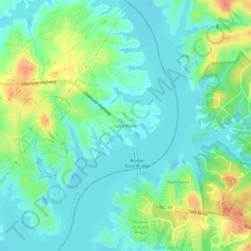
Name: Lake Wylie topographic map, elevation, terrain.
Average elevation: 188 m
Minimum elevation: 173 m
Maximum elevation: 219 m
Make a donation
Gear up for your next adventure:
As an Amazon Associate, this site earns from qualifying purchases at no extra cost to you.
Other topographic maps
Click on a map to view its topography, its elevation and its terrain.
Lake Wylie
United States > South Carolina > York County
Lake Wylie is located on a peninsula along the shore of Lake Wylie in the Piedmont of both North and South Carolina, at 35°6′22″N 81°3′25″W / 35.10611°N 81.05694°W / 35.10611; -81.05694 (35.105973, -81.056978). According to the United States Census Bureau, the CDP has a total area of 4.7…
Average elevation: 188 m
Rock Hill
United States > South Carolina > York County
Rock Hill is located along the Catawba River in the north-central section of the Piedmont of South Carolina, south of the city of Charlotte in North Carolina. The city sits at an elevation of around 676 feet (206 m) above sea level. It is located approximately 150 miles (240 km) from the Atlantic Ocean and 75…
Average elevation: 184 m
Kings Mountain State Park
United States > South Carolina > York County > Blacksburg
Average elevation: 240 m
Make a donation
Gear up for your next adventure:
As an Amazon Associate, this site earns from qualifying purchases at no extra cost to you.
Make a donation
Gear up for your next adventure:
As an Amazon Associate, this site earns from qualifying purchases at no extra cost to you.
Rock Hill
United States > South Carolina > York County
Rock Hill is located along the Catawba River in the north-central section of the Piedmont of South Carolina, south of the city of Charlotte in North Carolina. The city sits at an elevation of around 676 feet (206 m) above sea level. It is located approximately 150 miles (240 km) from the Atlantic Ocean and 75…
Average elevation: 184 m
Lake Wylie
United States > South Carolina > York County
Lake Wylie is located on a peninsula along the shore of Lake Wylie in the Piedmont of both North and South Carolina, at 35°6′22″N 81°3′25″W / 35.10611°N 81.05694°W / 35.10611; -81.05694 (35.105973, -81.056978). According to the United States Census Bureau, the CDP has a total area of 4.7…
Average elevation: 188 m
Make a donation
Gear up for your next adventure:
As an Amazon Associate, this site earns from qualifying purchases at no extra cost to you.
Kings Mountain National Military Park
United States > South Carolina > York County > Blacksburg
Average elevation: 241 m