Geolocate

Dahab topographic map

Click on the map to display elevation.

About this map

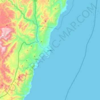
Name: Dahab topographic map, elevation, terrain.

Location: Dahab, South Sinai, 45214, Egypt (28.33636 34.35457 28.65636 34.67457)

Average elevation: 261 m

Minimum elevation: 0 m

Maximum elevation: 1,529 m

Other topographic maps

Click on a map to view its topography, its elevation and its terrain.

Al Tour City

Egypt > South Sinai

Average elevation: 50 m

Ras Sudr

Egypt > South Sinai

Average elevation: 17 m

Ras Muhammad National Park

Egypt > South Sinai

Average elevation: 112 m

Wadi Khuraytah

Egypt > South Sinai > Saint Catherine

Average elevation: 1,323 m

Ras Sudr

Egypt > South Sinai

Average elevation: 17 m

Gear up for your next adventure:

🔦UV Flashlight - Detect minerals or specific insects in the dark
🛏️Camping Sleeping Mat - Comfortable mats for sleeping outdoors
🛶Kayak Dry Bag - Waterproof storage for kayaking adventures
🧊Portable Cooler - Keep food and drinks cold during outdoor adventures
🧢Hiking Sun Hat - Wide-brimmed protection for exposed mountain ridges

As an Amazon Associate, this site earns from qualifying purchases at no extra cost to you.