
Thank you for supporting this site ❤️
Make a donation
Make a donation
Gear up for your next adventure:
As an Amazon Associate, this site earns from qualifying purchases at no extra cost to you.
Falken-Gesäß topographic map
Click on the map to display elevation.
Thank you for supporting this site ❤️
Make a donation
Make a donation
Gear up for your next adventure:
As an Amazon Associate, this site earns from qualifying purchases at no extra cost to you.
About this map
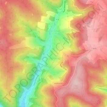
Name: Falken-Gesäß topographic map, elevation, terrain.
Location: Falken-Gesäß, Oberzent, Odenwaldkreis, Hessen, Deutschland (49.53861 8.90917 49.57593 8.95676)
Average elevation: 392 m
Minimum elevation: 236 m
Maximum elevation: 486 m
Thank you for supporting this site ❤️
Make a donation
Make a donation
Gear up for your next adventure:
As an Amazon Associate, this site earns from qualifying purchases at no extra cost to you.