Geolocate

Kingsville topographic map

Click on the map to display elevation.

About this map

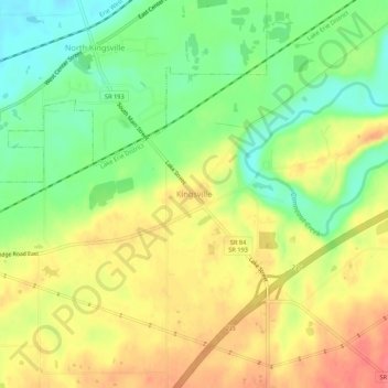
Name: Kingsville topographic map, elevation, terrain.

Location: Kingsville, Ashtabula County, Ohio, 44068, United States (41.87077 -80.69662 41.91077 -80.65662)

Average elevation: 226 m

Minimum elevation: 193 m

Maximum elevation: 258 m

Other topographic maps

Click on a map to view its topography, its elevation and its terrain.

Roaming Shores

United States > Ohio > Ashtabula County

Average elevation: 269 m

Rock Creek

United States > Ohio > Ashtabula County

Average elevation: 248 m

Edgewood

United States > Ohio > Ashtabula County

Average elevation: 214 m

North Kingsville

United States > Ohio > Ashtabula County

Average elevation: 198 m

Ashtabula

United States > Ohio > Ashtabula County

Average elevation: 200 m

Conneaut

United States > Ohio > Ashtabula County

Average elevation: 212 m

Geneva

United States > Ohio > Ashtabula County

Average elevation: 180 m

Jefferson

United States > Ohio > Ashtabula County

Average elevation: 285 m

Gear up for your next adventure:

🥾Trekking Boots - Durable boots for long-distance trekking
🔦LED Headlamp - Hands-free lighting for early morning starts or late finishes
🔦LED Headtorch - Bright and durable light for night activities
🦟Insect Repellent - Keep mosquitoes and black flies away in wooded areas
🧦Hiking Liner Socks - Thin base layer to prevent friction and blisters

As an Amazon Associate, this site earns from qualifying purchases at no extra cost to you.