
Krynica-Zdrój topographic map
Interactive map
Click on the map to display elevation.
About this map
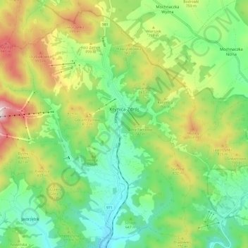
Name: Krynica-Zdrój topographic map, elevation, terrain.
Average elevation: 691 m
Minimum elevation: 492 m
Maximum elevation: 1,047 m
Other topographic maps
Click on a map to view its topography, its elevation and its terrain.
Ptaszkowa
Poland > Lesser Poland Voivodeship > Nowy Sącz County
Ptaszkowa, gmina Grybów, Nowy Sącz County, Lesser Poland Voivodeship, 33-333, Poland
Average elevation: 534 m