
Make a donation
Gear up for your next adventure:
As an Amazon Associate, this site earns from qualifying purchases at no extra cost to you.
Twin Lakes topographic map
Click on the map to display elevation.
Make a donation
Gear up for your next adventure:
As an Amazon Associate, this site earns from qualifying purchases at no extra cost to you.
About this map
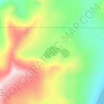
Name: Twin Lakes topographic map, elevation, terrain.
Location: Twin Lakes, Adams County, Idaho, United States (45.10087 -116.19066 45.10427 -116.18104)
Average elevation: 2,230 m
Minimum elevation: 1,940 m
Maximum elevation: 2,578 m
Make a donation
Gear up for your next adventure:
As an Amazon Associate, this site earns from qualifying purchases at no extra cost to you.
Other topographic maps
Click on a map to view its topography, its elevation and its terrain.
New Meadows
United States > Idaho > Adams County
New Meadows is located at 44°58′13″N 116°17′7″W / 44.97028°N 116.28528°W / 44.97028; -116.28528 (44.970405, -116.285283), at an elevation of 3,868 feet (1,179 m) above sea level.
Average elevation: 1,184 m