Geolocate

Ciledug topographic map

Click on the map to display elevation.

About this map

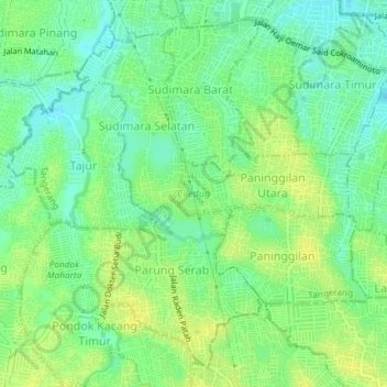
Name: Ciledug topographic map, elevation, terrain.

Location: Ciledug, Tangerang, Banten, Java, Indonesia (-6.25762 106.68654 -6.22466 106.72339)

Average elevation: 22 m

Minimum elevation: 12 m

Maximum elevation: 31 m

Other topographic maps

Click on a map to view its topography, its elevation and its terrain.

East Asia

Indonesia > Banten > Tangerang

Average elevation: 12 m

East Asia

Indonesia > Banten > Tangerang

Average elevation: 12 m

West Europe

Indonesia > Banten > Tangerang

Average elevation: 9 m

Gear up for your next adventure:

🩹Compact First Aid Kit - Pre-packed essentials for common trail injuries
🥾Light Hiking Boots - Lightweight and comfortable boots for day hikes
🧢Outdoor Visor - Breathable visor for sunny hikes
🚑Survival Whistle - Signal for help across long distances in mountains
🧥Thermal Fleece Jacket - Versatile insulation for changing mountain temperatures

As an Amazon Associate, this site earns from qualifying purchases at no extra cost to you.