
Wanzhou topographic map
Click on the map to display elevation.
Wanzhou
Wanzhou spans 30°24′−31°14′ N latitude and 107°55′−108°53′ E longitude, and is situated at the eastern edge of the Sichuan Basin. It reaches a maximal north–south extent of 67.25 km (41.79 mi) and east–west width of 97.25 km (60.43 mi), covering an area of 3,214 km2 (1,241 sq mi). Elevations range from 106 m (348 ft) in the town of Tailong (太龙镇) to 1,762 m (5,781 ft) at Shaping Peak (沙坪峰) of the Qiyao Mountains (齐曜山). Bordering county-level divisions.
About this map
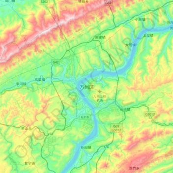
Name: Wanzhou topographic map, elevation, terrain.
Average elevation: 504 m
Minimum elevation: 91 m
Maximum elevation: 1,345 m