
Make a donation
Gear up for your next adventure:
As an Amazon Associate, this site earns from qualifying purchases at no extra cost to you.
Ghirlanda topographic map
Click on the map to display elevation.
Make a donation
Gear up for your next adventure:
As an Amazon Associate, this site earns from qualifying purchases at no extra cost to you.
About this map
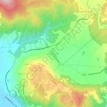
Name: Ghirlanda topographic map, elevation, terrain.
Location: Ghirlanda, Massa Marittima, Grosseto, Toskana, 58024, Italien (43.03751 10.88147 43.07751 10.92147)
Average elevation: 313 m
Minimum elevation: 160 m
Maximum elevation: 541 m
Make a donation
Gear up for your next adventure:
As an Amazon Associate, this site earns from qualifying purchases at no extra cost to you.
Other topographic maps
Click on a map to view its topography, its elevation and its terrain.
Make a donation
Gear up for your next adventure:
As an Amazon Associate, this site earns from qualifying purchases at no extra cost to you.
Scansano
Dokumentiert sind die Ortsteile Murci (918) und Montorgiali (1188 von Papst Clemens III., damaliger Hauptort der Grafschaft) bereits vor dem heutigen Hauptort Scansano, der erst 1272 schriftlich erwähnt wird. Scansano entstand als Burg (Castello, heute nicht mehr vorhanden) auf einer Anhöhe zwischen dem…
Average elevation: 243 m
Cinigiano
Zu seinen Ortsteilen zählen Borgo Santa Rita (102 Höhenmeter, ca. 40 Einwohner), Castiglioncello Bandini (606 m, ca. 100 Einwohner), Monticello Amiata (734 m, mit über 400 Einwohnern der größte Ortsteil), Poggi del Sasso (349 m, ca. 90 Einwohner), Porrona (254 m, ca. 20 Einwohner) und Sasso d’Ombrone…
Average elevation: 268 m
Make a donation
Gear up for your next adventure:
As an Amazon Associate, this site earns from qualifying purchases at no extra cost to you.