Geolocate

Friday Harbor topographic map

Click on the map to display elevation.

About this map
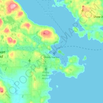
Name: Friday Harbor topographic map, elevation, terrain.

Location: Friday Harbor, San Juan County, Washington, 98250, United States (48.52172 -123.14262 48.55666 -123.00124)

Average elevation: 28 m

Minimum elevation: -2 m

Maximum elevation: 155 m

Other topographic maps

Click on a map to view its topography, its elevation and its terrain.

Decatur

United States > Washington > San Juan County

Average elevation: 23 m

Eastsound

United States > Washington > San Juan County

Average elevation: 74 m

Canoe Island

United States > Washington > San Juan County

Canoe Island is a 47-acre (19-hectare) island located in the center of the San Juan Islands, an archipelago in the U.S. state of Washington. The island is situated in Upright Channel between Shaw and Lopez Islands. Canoe Island's surface is mostly forested with second-growth cedar, fir, hemlock, and madrona,…

Average elevation: 11 m

Eastsound

United States > Washington > San Juan County

Average elevation: 74 m

Olga

United States > Washington > San Juan County

Average elevation: 55 m

Gear up for your next adventure:

🛁Quick-Dry Microfiber Towel - Space-saving towel that dries rapidly on the move
☕Camping Coffee Maker - Brew fresh coffee anywhere on the topographic map
🧊Portable Cooler - Keep food and drinks cold during outdoor adventures
🧼Biodegradable Camp Soap - Environmentally friendly cleaning for gear and body
🧥Waterproof Hiking Jacket - Protect yourself from rain and wind while hiking

As an Amazon Associate, this site earns from qualifying purchases at no extra cost to you.