
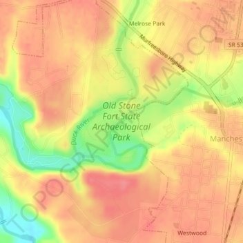
Old Stone Fort State Archaeological Park topographic map
Interactive map
Click on the map to display elevation.
About this map
Name: Old Stone Fort State Archaeological Park topographic map, elevation, terrain.
Average elevation: 316 m
Minimum elevation: 268 m
Maximum elevation: 339 m
The Duck River system spills over a limestone-rich shelf of the western Cumberland Plateau known as the Highland Rim. As the Duck and Little Duck approach their convergence, they rapidly drop in elevation, and have cut relatively deep gorges around the peninsula upon which the ancient structure is located. Both gorges are highlighted by a series of substantial waterfalls and whitewater rapids. The natural waterpower in these two gorges attracted entrepreneurs and millwrights throughout the 19th century.
Other topographic maps
Click on a map to view its topography, its elevation and its terrain.
Glenview
United States > Tennessee > Coffee County > Manchester
Glenview, Manchester, Coffee County, Middle Tennessee, Tennessee, 37355, United States
Average elevation: 322 m
White Oaks
United States > Tennessee > Coffee County > Manchester
White Oaks, Manchester, Coffee County, Tennessee, 38505, United States
Average elevation: 325 m
Belmont
United States > Tennessee > Coffee County > Manchester
Belmont, Manchester, Coffee County, Middle Tennessee, Tennessee, United States
Average elevation: 320 m
Royal Oaks
United States > Tennessee > Coffee County > Manchester > Royal Oaks
Royal Oaks, Manchester, Coffee County, Tennessee, 38505, United States
Average elevation: 326 m
Westwood
United States > Tennessee > Coffee County > Manchester > Westwood
Westwood, Manchester, Coffee County, Tennessee, 37183:37355, United States
Average elevation: 322 m