
Make a donation
Gear up for your next adventure:
As an Amazon Associate, this site earns from qualifying purchases at no extra cost to you.
Chaclacayo topographic map
Click on the map to display elevation.
Make a donation
Gear up for your next adventure:
As an Amazon Associate, this site earns from qualifying purchases at no extra cost to you.
Chaclacayo
El distrito de Chaclacayo se localiza a 11° 58' Latitud Sur, 76° 46' Longitud Oeste a una altitud de 647 m s. n. m., ubicado a 27 km del centro de Lima por la Carretera Central. Limita separándose por el río Rímac al norte y al este con el distrito de Lurigancho-Chosica, al sur con el distrito de Cieneguilla y al oeste con el distrito de Ate.
Make a donation
Gear up for your next adventure:
As an Amazon Associate, this site earns from qualifying purchases at no extra cost to you.
About this map
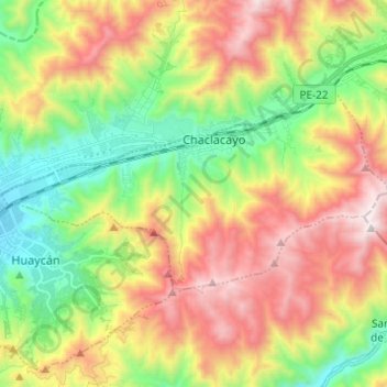
Name: Chaclacayo topographic map, elevation, terrain.
Location: Chaclacayo, Lima, Lima Metropolitana, Lima, Perú (-12.02325 -76.83720 -11.96155 -76.71479)
Average elevation: 1,048 m
Minimum elevation: 505 m
Maximum elevation: 1,761 m
Make a donation
Gear up for your next adventure:
As an Amazon Associate, this site earns from qualifying purchases at no extra cost to you.
Other topographic maps
Click on a map to view its topography, its elevation and its terrain.