
Lee Vining topographic map
Click on the map to display elevation.
Lee Vining
Lee Vining (formerly Leevining, Poverty Flat, and Lakeview) is an unincorporated community and census-designated place (CDP) in Mono County, California, United States. It is located 25 miles (40 km) south-southeast of Bridgeport, at an elevation of 6,781 feet (2,067 m). Lee Vining is located on the southwest shore of Mono Lake. The population was 217 as of the 2020 census.
About this map
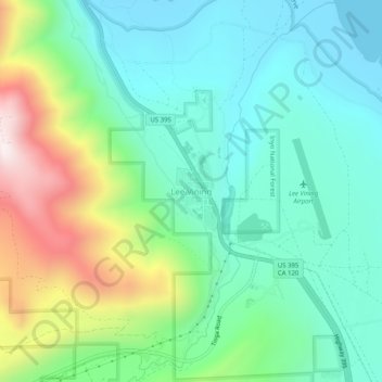
Name: Lee Vining topographic map, elevation, terrain.
Location: Lee Vining, Mono County, California, 93541, United States (37.93743 -119.14182 37.97743 -119.10182)
Average elevation: 2,180 m
Minimum elevation: 1,945 m
Maximum elevation: 2,768 m
Other topographic maps
Click on a map to view its topography, its elevation and its terrain.
Mono Lake
United States > California > Mono County
Lake Russell was the prehistoric predecessor to Mono Lake, during the Pleistocene. Its shoreline reached the modern-day elevation of 7,480 feet (2,280 m), about 1,100 feet (330 m) higher than the present-day lake. As of 1.6 million years ago, Lake Russell discharged to the northeast, into the Walker River…
Average elevation: 2,008 m