
Make a donation
Gear up for your next adventure:
As an Amazon Associate, this site earns from qualifying purchases at no extra cost to you.
Groß-Umstadt topographic map
Click on the map to display elevation.
Make a donation
Gear up for your next adventure:
As an Amazon Associate, this site earns from qualifying purchases at no extra cost to you.
Groß-Umstadt
Groß-Umstadt liegt im südlichen Hessen am nordöstlichen Rand des Odenwalds und am südlichen Rand des Rhein-Main-Gebiets. Die höchste Erhebung der Stadt ist der Heidelberg mit 365 m ü.NN (südöstlich des Stadtteils Wiebelsbach), die höchste Erhebung der Gemarkung Groß-Umstadt die Alte Höhe mit 358 m ü.NN (in östlicher Richtung zum Stadtteil Dorndiel).
Make a donation
Gear up for your next adventure:
As an Amazon Associate, this site earns from qualifying purchases at no extra cost to you.
About this map
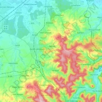
Name: Groß-Umstadt topographic map, elevation, terrain.
Average elevation: 206 m
Minimum elevation: 128 m
Maximum elevation: 375 m
Make a donation
Gear up for your next adventure:
As an Amazon Associate, this site earns from qualifying purchases at no extra cost to you.