
Make a donation
Gear up for your next adventure:
As an Amazon Associate, this site earns from qualifying purchases at no extra cost to you.
Jaipur topographic map
Click on the map to display elevation.
Make a donation
Gear up for your next adventure:
As an Amazon Associate, this site earns from qualifying purchases at no extra cost to you.
About this map
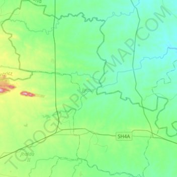
Name: Jaipur topographic map, elevation, terrain.
Location: Jaipur, Purulia District, Bengale-Occidental, Inde (23.35940 86.01387 23.58639 86.24722)
Average elevation: 266 m
Minimum elevation: 191 m
Maximum elevation: 565 m
Make a donation
Gear up for your next adventure:
As an Amazon Associate, this site earns from qualifying purchases at no extra cost to you.
Other topographic maps
Click on a map to view its topography, its elevation and its terrain.
Make a donation
Gear up for your next adventure:
As an Amazon Associate, this site earns from qualifying purchases at no extra cost to you.
Tiger Hill
Inde > Bengale-Occidental > Jorebunglow Sukiapokhri > Rangli Rangliot
Average elevation: 2,275 m
Make a donation
Gear up for your next adventure:
As an Amazon Associate, this site earns from qualifying purchases at no extra cost to you.