
Make a donation
Gear up for your next adventure:
As an Amazon Associate, this site earns from qualifying purchases at no extra cost to you.
Black Jack topographic map
Click on the map to display elevation.
Make a donation
Gear up for your next adventure:
As an Amazon Associate, this site earns from qualifying purchases at no extra cost to you.
About this map
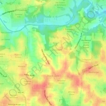
Name: Black Jack topographic map, elevation, terrain.
Location: Black Jack, Saint Louis County, Missouri, United States (38.78310 -90.27957 38.81896 -90.25048)
Average elevation: 170 m
Minimum elevation: 141 m
Maximum elevation: 195 m
Make a donation
Gear up for your next adventure:
As an Amazon Associate, this site earns from qualifying purchases at no extra cost to you.
Other topographic maps
Click on a map to view its topography, its elevation and its terrain.
Creve Coeur Lake
United States > Missouri > Saint Louis County > Maryland Heights
Average elevation: 150 m
Make a donation
Gear up for your next adventure:
As an Amazon Associate, this site earns from qualifying purchases at no extra cost to you.
Jefferson Barracks
United States > Missouri > Saint Louis County > Jefferson Barracks
Average elevation: 140 m
Make a donation
Gear up for your next adventure:
As an Amazon Associate, this site earns from qualifying purchases at no extra cost to you.
Simpson Park Lake
United States > Missouri > Saint Louis County > Valley Park
Average elevation: 138 m
Make a donation
Gear up for your next adventure:
As an Amazon Associate, this site earns from qualifying purchases at no extra cost to you.
Sioux Passage Park
United States > Missouri > Saint Louis County > Old Jamestown > Possum Hollow
Average elevation: 150 m
Make a donation
Gear up for your next adventure:
As an Amazon Associate, this site earns from qualifying purchases at no extra cost to you.
Greentree Park
United States > Missouri > Saint Louis County > Kirkwood > Osage Hills
Average elevation: 151 m
Pattonville
United States > Missouri > Saint Louis County > Bridgeton > Pattonville
Average elevation: 174 m