Geolocate

Benton topographic map

Interactive map

Click on the map to display elevation.

About this map

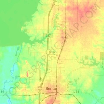
Name: Benton topographic map, elevation, terrain.

Location: Benton, Franklin County, Illinois, 62812, United States (37.98205 -88.94754 38.08010 -88.88784)

Average elevation: 132 m

Minimum elevation: 108 m

Maximum elevation: 156 m

Other topographic maps

Click on a map to view its topography, its elevation and its terrain.

Benton Park

United States > Illinois > Franklin County > Benton

Benton Park, Benton, Franklin County, Illinois, 62897, United States

Average elevation: 138 m

Christopher

United States > Illinois > Franklin County

Christopher, Franklin County, Illinois, 62822, United States

Average elevation: 130 m

West Frankfort

United States > Illinois > Franklin County

West Frankfort, Franklin County, Illinois, 62896, United States

Average elevation: 122 m

Thompsonville

United States > Illinois > Franklin County

Thompsonville, Franklin County, Illinois, United States

Average elevation: 147 m

Royalton

United States > Illinois > Franklin County > Royalton

Royalton, Franklin County, Illinois, United States

Average elevation: 122 m

Rend Lake

United States > Illinois > Franklin County

Rend Lake, Franklin County, Illinois, United States

Average elevation: 132 m