Geolocate

Baeza topographic map

Click on the map to display elevation.

About this map

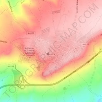
Name: Baeza topographic map, elevation, terrain.

Location: Baeza, Jaén, Andalucía, 23440, España (37.98527 -3.48617 38.00586 -3.44120)

Average elevation: 714 m

Minimum elevation: 561 m

Maximum elevation: 787 m

Other topographic maps

Click on a map to view its topography, its elevation and its terrain.

Puente del Obispo

España > Andalucía > Baeza

Average elevation: 329 m

La Yedra

España > Andalucía > Baeza

Average elevation: 689 m

Gear up for your next adventure:

🧥Insulated Jacket - Keep warm in cold outdoor conditions
🔨Vehicle Emergency Tool - Safety tool for remote road trips to trailheads
💡LED Camping Lantern - Illuminate your campsite with long-lasting lanterns
🕯️Camping Lantern - Illuminates your entire campsite with high-efficiency LEDs
🚲Bike Repair Kit - Essential tools for on-trail mechanical issues

As an Amazon Associate, this site earns from qualifying purchases at no extra cost to you.