
Thank you for supporting this site ❤️
Make a donation
Make a donation
Gear up for your next adventure:
As an Amazon Associate, this site earns from qualifying purchases at no extra cost to you.
Trabes topographic map
Click on the map to display elevation.
Thank you for supporting this site ❤️
Make a donation
Make a donation
Gear up for your next adventure:
As an Amazon Associate, this site earns from qualifying purchases at no extra cost to you.
About this map
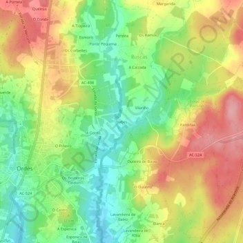
Name: Trabes topographic map, elevation, terrain.
Location: Trabes, Buscás, Ordes, A Corogne, Galice, 15689, Espagne (43.06443 -8.40599 43.10443 -8.36599)
Average elevation: 312 m
Minimum elevation: 253 m
Maximum elevation: 377 m
Thank you for supporting this site ❤️
Make a donation
Make a donation
Gear up for your next adventure:
As an Amazon Associate, this site earns from qualifying purchases at no extra cost to you.