Geolocate

Widnes topographic map

Click on the map to display elevation.

About this map

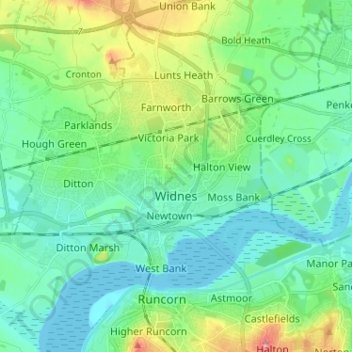
Name: Widnes topographic map, elevation, terrain.

Location: Widnes, Halton, Liverpool City Region, England, United Kingdom (53.33554 -2.81881 53.40254 -2.69063)

Average elevation: 24 m

Minimum elevation: 0 m

Maximum elevation: 95 m

Other topographic maps

Click on a map to view its topography, its elevation and its terrain.

Runcorn

United Kingdom > England > Halton

Average elevation: 22 m

Widnes

United Kingdom > England > Halton

Average elevation: 24 m

Weston

United Kingdom > England > Halton > Weston

Average elevation: 27 m

Oxmoor Wood

United Kingdom > England > Halton > Runcorn

Average elevation: 12 m

Preston on the Hill

United Kingdom > England > Halton

Average elevation: 50 m

Gear up for your next adventure:

🏕️Camping Hammock - Integrated protection for sleeping between trees
🧦Hiking Liner Socks - Thin base layer to prevent friction and blisters
Tent Footprint - Protect tent floor and increase durability
Family Camping Tent - Spacious tent suitable for family camping trips
🧢Outdoor Visor - Breathable visor for sunny hikes

As an Amazon Associate, this site earns from qualifying purchases at no extra cost to you.