
Make a donation
Gear up for your next adventure:
As an Amazon Associate, this site earns from qualifying purchases at no extra cost to you.
Norwood topographic map
Click on the map to display elevation.
Make a donation
Gear up for your next adventure:
As an Amazon Associate, this site earns from qualifying purchases at no extra cost to you.
About this map
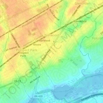
Name: Norwood topographic map, elevation, terrain.
Location: Norwood, Delaware County, Pennsylvania, 19074, United States (39.87686 -75.30650 39.89808 -75.28630)
Average elevation: 19 m
Minimum elevation: -4 m
Maximum elevation: 36 m
Make a donation
Gear up for your next adventure:
As an Amazon Associate, this site earns from qualifying purchases at no extra cost to you.
Other topographic maps
Click on a map to view its topography, its elevation and its terrain.
Springfield
United States > Pennsylvania > Delaware County > Springfield Township > Springfield
Average elevation: 58 m
Saint Davids
United States > Pennsylvania > Delaware County > Radnor Township
Average elevation: 122 m
Make a donation
Gear up for your next adventure:
As an Amazon Associate, this site earns from qualifying purchases at no extra cost to you.
Crum Creek Manor
United States > Pennsylvania > Delaware County > Nether Providence Township
Average elevation: 38 m
Make a donation
Gear up for your next adventure:
As an Amazon Associate, this site earns from qualifying purchases at no extra cost to you.
Merwood Park
United States > Pennsylvania > Delaware County > Haverford Township > Coreze
Average elevation: 99 m
Ardmore Park
United States > Pennsylvania > Delaware County > Haverford Township
Average elevation: 95 m
South Media
United States > Pennsylvania > Delaware County > Nether Providence Township
Average elevation: 65 m
Dilworthtown
United States > Pennsylvania > Delaware County > Chadds Ford Township
Average elevation: 122 m
Make a donation
Gear up for your next adventure:
As an Amazon Associate, this site earns from qualifying purchases at no extra cost to you.
Johnsons Corner
United States > Pennsylvania > Delaware County > Concord Township
Average elevation: 116 m
Pilgrim Gardens
United States > Pennsylvania > Delaware County > Haverford Township
Average elevation: 76 m
Make a donation
Gear up for your next adventure:
As an Amazon Associate, this site earns from qualifying purchases at no extra cost to you.
Glen Riddle
United States > Pennsylvania > Delaware County > Middletown Township
Average elevation: 69 m
Make a donation
Gear up for your next adventure:
As an Amazon Associate, this site earns from qualifying purchases at no extra cost to you.