Geolocate

Paderborn topographic map

Click on the map to display elevation.

About this map

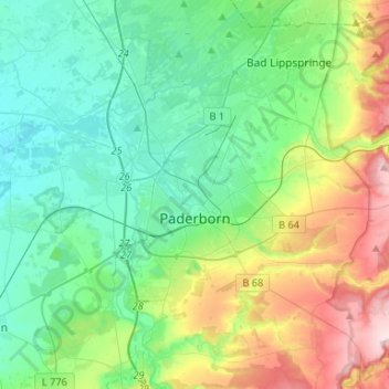
Name: Paderborn topographic map, elevation, terrain.

Location: Paderborn, Kreis Paderborn, North Rhine-Westphalia, Germany (51.65423 8.63629 51.80084 8.90059)

Average elevation: 164 m

Minimum elevation: 89 m

Maximum elevation: 362 m

Gear up for your next adventure:

🧢Outdoor Cap - Protective cap for sun and rain during hikes
🥘Camping Cookware Set - Compact nesting pots and pans for trail cooking
🛌Down Sleeping Bag - Superior warmth-to-weight ratio for cold nights
🥾All-Terrain Hiking Boots - Versatile boots for varied hiking conditions
🥫Freeze-Dried Meals - Lightweight, high-calorie nutrition for multi-day treks

As an Amazon Associate, this site earns from qualifying purchases at no extra cost to you.