Geolocate

Marburg topographic map

Click on the map to display elevation.

About this map

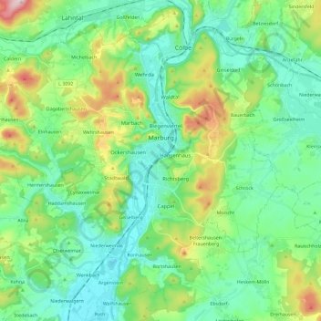
Name: Marburg topographic map, elevation, terrain.

Location: Marburg, Landkreis Marburg-Biedenkopf, Hesse, Germany (50.73803 8.62742 50.85873 8.85812)

Average elevation: 245 m

Minimum elevation: 164 m

Maximum elevation: 474 m

Gear up for your next adventure:

Lightweight Camping Tent - Portable shelter optimized for Canadian backcountry camping
🥾Waterproof Hiking Shoes - Durable shoes for wet and rugged trails
🔭Compact Monocular - One-handed bird watching and trail spotting
🦌Outdoor Trail Camera - Monitor wildlife activity near your favorite spots
Tent Footprint - Protect tent floor and increase durability

As an Amazon Associate, this site earns from qualifying purchases at no extra cost to you.