Geolocate

Bucal II topographic map

Click on the map to display elevation.

About this map

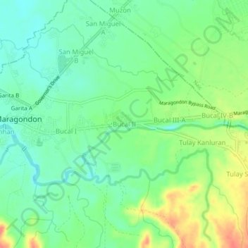
Name: Bucal II topographic map, elevation, terrain.

Location: Bucal II, Maragondon, Cavite, Calabarzon, 4112, Philippines (14.25330 120.73272 14.29330 120.77272)

Average elevation: 28 m

Minimum elevation: 6 m

Maximum elevation: 65 m

Other topographic maps

Click on a map to view its topography, its elevation and its terrain.

Patungan

Philippines > Cavite > Maragondon

Average elevation: 102 m

Patungan

Philippines > Cavite > Maragondon

Average elevation: 114 m

Maragondon River

Philippines > Cavite > Maragondon > Bucal III-B

Average elevation: 28 m

Gear up for your next adventure:

🥾Trekking Boots - Durable boots for long-distance trekking
🪑Insulated Seat Pad - Protect your seat from cold rocks and wet logs
🥤Collapsible Travel Cup - Saves space and weight in your mess kit
🥾Light Trekking Boots - Supportive boots for multi-day treks
💧Collapsible Water Bottle - Space-saving water bottle for outdoor activities

As an Amazon Associate, this site earns from qualifying purchases at no extra cost to you.