Geolocate

Bongol topographic map

Click on the map to display elevation.

About this map

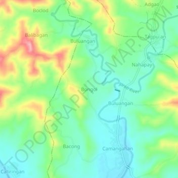
Name: Bongol topographic map, elevation, terrain.

Location: Bongol, Guimbal, Iloilo, Western Visayas, 5022, Philippines (10.70328 122.28503 10.74328 122.32503)

Average elevation: 74 m

Minimum elevation: 25 m

Maximum elevation: 172 m

Other topographic maps

Click on a map to view its topography, its elevation and its terrain.

Jarao River

Philippines > Iloilo > Guimbal > Sipitan-Badlang

Average elevation: 67 m

Gear up for your next adventure:

🥾Trail Hiking Shoes - Durable shoes designed for rugged trails
🔦LED Headtorch - Bright and durable light for night activities
📷Outdoor Action Camera - Capture high-elevation views and rugged adventures
🩹Compact First Aid Kit - Pre-packed essentials for common trail injuries
🦶Hiking Shoe Insoles - Added support for high arches and long days on feet

As an Amazon Associate, this site earns from qualifying purchases at no extra cost to you.