Geolocate

Masi topographic map

Click on the map to display elevation.

About this map

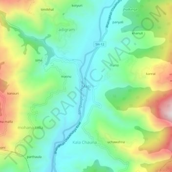
Name: Masi topographic map, elevation, terrain.

Location: Masi, Chaukhutiya, Almora District, Uttarakhand, 263658, India (29.79827 79.26147 29.83827 79.30147)

Average elevation: 1,060 m

Minimum elevation: 842 m

Maximum elevation: 1,501 m

Gear up for your next adventure:

Camping Tent - Weather-resistant tents suitable for 2 to 6 people
🥾Trail Hiking Boots - Supportive boots for rough trails
🥾Light Hiking Boots - Lightweight and comfortable boots for day hikes
🧼Biodegradable Camp Soap - Environmentally friendly cleaning for gear and body
🧢Outdoor Cap - Protective cap for sun and rain during hikes

As an Amazon Associate, this site earns from qualifying purchases at no extra cost to you.