Geolocate

Silago topographic map

Click on the map to display elevation.

About this map

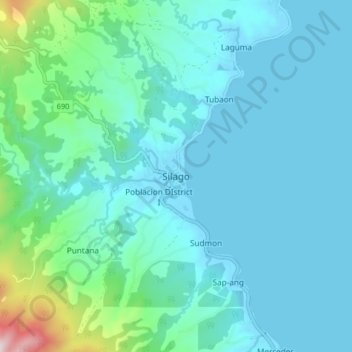
Name: Silago topographic map, elevation, terrain.

Location: Silago, Southern Leyte, Eastern Visayas, Philippines (10.48854 125.12232 10.56854 125.20232)

Average elevation: 106 m

Minimum elevation: -2 m

Maximum elevation: 763 m

Other topographic maps

Click on a map to view its topography, its elevation and its terrain.

Macrohon

Philippines > Southern Leyte

Average elevation: 33 m

Padre Burgos

Philippines > Southern Leyte

Average elevation: 38 m

Gear up for your next adventure:

🔦LED Headlamp - Hands-free lighting for early morning starts or late finishes
🧭GPS Handheld Device - Reliable GPS navigation for outdoor adventures
🛶Waterproof Dry Bags - Keep electronics and clothes dry during river crossings
🛁Quick-Dry Microfiber Towel - Space-saving towel that dries rapidly on the move
🧤Insulated Winter Gloves - Heavy-duty protection for sub-zero Canadian adventures

As an Amazon Associate, this site earns from qualifying purchases at no extra cost to you.