
Make a donation
Gear up for your next adventure:
As an Amazon Associate, this site earns from qualifying purchases at no extra cost to you.
Rheinsberg topographic map
Click on the map to display elevation.
Make a donation
Gear up for your next adventure:
As an Amazon Associate, this site earns from qualifying purchases at no extra cost to you.
Rheinsberg
Von 1919 bis 1925 wurde die Gartenstadt, Werkssiedlung Rhinhöhe für die Belegschaft der Keramikfabrik Christian Carstens KG an der Lindenallee gebaut. Die Gartenstadt umfasste ursprünglich 29 Einfamilienhäuser, 13 Doppelhäuser und ein Ledigenwohnheim. Besondere Dachformen zeichnen die Bauform der Siedlung aus. Das Großunternehmen Carstens besaß mehrere Keramikwerke und 14 Porzellanfabriken, es war nach Villeroy & Boch der zweitgrößte Keramikproduzent in Deutschland. Der Vertrieb hatte Überseehandel.
Make a donation
Gear up for your next adventure:
As an Amazon Associate, this site earns from qualifying purchases at no extra cost to you.
About this map
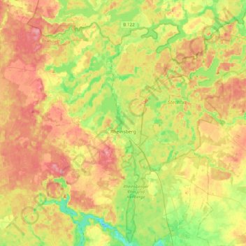
Name: Rheinsberg topographic map, elevation, terrain.
Location: Rheinsberg, Ostprignitz-Ruppin, Brandenburg, Deutschland (53.00140 12.64163 53.21007 13.02816)
Average elevation: 72 m
Minimum elevation: 30 m
Maximum elevation: 115 m
Make a donation
Gear up for your next adventure:
As an Amazon Associate, this site earns from qualifying purchases at no extra cost to you.