
Make a donation
Gear up for your next adventure:
As an Amazon Associate, this site earns from qualifying purchases at no extra cost to you.
Casselman topographic map
Click on the map to display elevation.
Make a donation
Gear up for your next adventure:
As an Amazon Associate, this site earns from qualifying purchases at no extra cost to you.
About this map
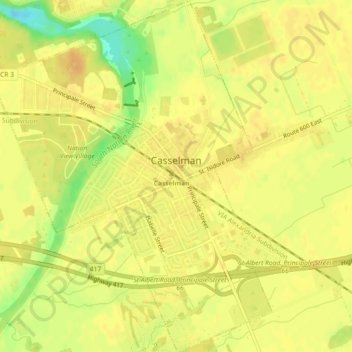
Name: Casselman topographic map, elevation, terrain.
Average elevation: 64 m
Minimum elevation: 41 m
Maximum elevation: 72 m
Make a donation
Gear up for your next adventure:
As an Amazon Associate, this site earns from qualifying purchases at no extra cost to you.
Other topographic maps
Click on a map to view its topography, its elevation and its terrain.
Sainte-Anne-de-Prescott
Canada > Ontario > Comtés unis de Prescott et Russell > East Hawkesbury
Average elevation: 67 m
Vankleek Hill
Canada > Ontario > Comtés unis de Prescott et Russell > Champlain
Average elevation: 96 m
Make a donation
Gear up for your next adventure:
As an Amazon Associate, this site earns from qualifying purchases at no extra cost to you.
Treadwell
Canada > Ontario > Comtés unis de Prescott et Russell > Alfred and Plantagenet
Average elevation: 53 m
Saint-Eugène
Canada > Ontario > Comtés unis de Prescott et Russell > East Hawkesbury
Average elevation: 59 m
Alfred
Canada > Ontario > Comtés unis de Prescott et Russell > Alfred and Plantagenet > Alfred
Average elevation: 64 m
Make a donation
Gear up for your next adventure:
As an Amazon Associate, this site earns from qualifying purchases at no extra cost to you.
Chute-à-Blondeau
Canada > Ontario > Comtés unis de Prescott et Russell > East Hawkesbury
Average elevation: 56 m