Geolocate

Linyi topographic map

Click on the map to display elevation.

About this map

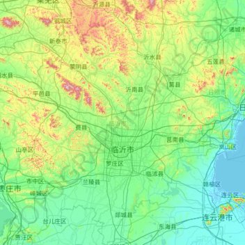
Name: Linyi topographic map, elevation, terrain.

Location: Linyi, Lanshan District, Shandong, China (34.37858 117.41112 36.20646 119.19512)

Average elevation: 140 m

Minimum elevation: -2 m

Maximum elevation: 1,059 m

Gear up for your next adventure:

🔋Emergency Crank Radio - Weather alerts and power without needing batteries
🎒Fully Waterproof Backpack - Total protection for photography gear and electronics
🧴First Aid Kit - Essential first aid supplies for outdoor emergencies
🧦Crew Hiking Socks - Comfortable socks for long-distance hikes
🥾Light Hiking Boots - Lightweight and comfortable boots for day hikes

As an Amazon Associate, this site earns from qualifying purchases at no extra cost to you.