Geolocate

Moncrief topographic map

Click on the map to display elevation.

About this map

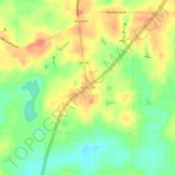
Name: Moncrief topographic map, elevation, terrain.

Location: Moncrief, Grady County, Georgia, United States (30.69270 -84.15740 30.73270 -84.11740)

Average elevation: 66 m

Minimum elevation: 37 m

Maximum elevation: 94 m

Other topographic maps

Click on a map to view its topography, its elevation and its terrain.

Tired Creek Lake

United States > Georgia > Grady County

Average elevation: 80 m

Cairo

United States > Georgia > Grady County

Average elevation: 76 m

Tired Creek Lake

United States > Georgia > Grady County

Average elevation: 80 m

Lake Dewitt Dam

United States > Georgia > Grady County

Average elevation: 58 m

Whigham

United States > Georgia > Grady County

Average elevation: 85 m

Cairo

United States > Georgia > Grady County

Average elevation: 76 m

Gear up for your next adventure:

🔥Emergency Fire Starter - Reliable ignition source for all weather conditions
🥾Trail Hiking Shoes - Durable shoes designed for rugged trails
🥾Hiking Shorts - Breathable shorts suitable for summer hikes
🎒Hiking Backpack - Lightweight and ergonomic backpacks for day hikes or multi-day treks
👟Sport Hiking Sandals - Breathable footwear for water crossings and camp rest

As an Amazon Associate, this site earns from qualifying purchases at no extra cost to you.